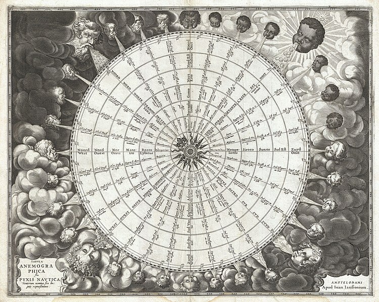
Mynd:1650 Jansson Wind Rose, Anemographic Chart, or Map of the Winds - Geographicus - Anemographica-jannson-1650.jpg

Frá SignWiki
Jump to navigation Jump to search

Upprunafíla(5,000 × 3,995 pixel, stødd fílu: 7.38 MB, MIME-slag: image/jpeg)

Henda fíla er frá Wikimedia Commons og kann verða brúka í øðrum verkætlanum. Frágreiðingin á fílu frágreiðingar síðu er víst her niðanfyri.

Jan Janssonius: Tabula Anemographica seu Pyxis Nautica Ventorum Nomina Sex Linguis Repraesentans.   (Wikidata search (Cirrus search) Wikidata query (SPARQL)  Create new Wikidata item based on this file)
Artist
Jan Janssonius  (1588–1664)  wikidata:Q949492 s:it:Autore:Johannes Janssonius
 
Alternative names
Jan Jansson, Jan Jansz, Jan Janszoon, Joannes Janssonius
Description Dutch kortteknari, publisher, printseller og visual artist
Date of birth/death 1588 Edit this at Wikidata 11 juli 1664 / 1664 Edit this at Wikidata
Location of birth/death Arnhem Amsterdam
Work period 1616 - 1664
date QS:P,+1650-00-00T00:00:00Z/7,P580,+1616-00-00T00:00:00Z/9,P582,+1664-00-00T00:00:00Z/9
Work location
Amsterdam (1612–1664); Arnhem (1612–1612) Edit this at Wikidata
Authority file
artist QS:P170,Q949492
Title
Tabula Anemographica seu Pyxis Nautica Ventorum Nomina Sex Linguis Repraesentans.
Frágreiðing
English: An exceptionally rare example of one of the earliest and most significant anemographic, or wind rose, charts to appear in the 17th century. This unusual chart represents a transitional point in the perception of direction, or to be precise, the transition from the wind rose to the compass rose. Early mariners in the Mediterranean defined direction by the names the various winds and the points from which they blew. This idea traces its roots to ancient Greece. Homer identified four cardinal winds, but as navigation and cartography advanced, more were added. This chart represents a full thirty-two named winds and a multitude of different wind systems. Each of the winds is identified by several different names in Greek, Latin, French, and Dutch. Each wind is additionally attached to both contemporary compass points, north west east and south, and a more sophisticated circle and degree system. In the areas surrounding the sphere, each wind is personified by a figure bearing the racial characteristics associated with the region or direction represented. The upper left quadrant, representing north, depicts bearded Germans or Scandinavians. The upper right, representing east, shows beardless dark skinned faces. The beardless and pale skinned figures in the lower left and right, representing west and south, are less distinguishable but may be intended to represent indigenous Americans and Greeks. Anemographic charts, like this, were functional objects and valuable reference tools. Early navigators, referring to the directions as winds, might sail by the north wind. This was exceptionally practical when trade winds dictated ocean commerce. A warm wind from the south, for example might suggest that certain routes, closed for part of the year, were now open. A navigator would have used this chart to compare different names for directions. So, he may be using a chart made in Greece that identified the winds by the names of Greek gods, but himself been trained to use to a different, say Catalan or English, nomenclature. With this chart, he could figure out what various sailing logs and navigation books were referring to. Remember, while nautical charts did exist in the 1600s, most navigation was accomplished using Pilot Books that had instructions like this follow the south wind for 3 days before turning with the eastern wind etc. Thus this was a very useful object indeed. This chart was published as plate 1 in Jansonnius' 1650 Atlas Maritimus or volume 5 in his Atlantis Majoris .
Dagur 1650 (undated)
Dimensions hædd: 17,5 in (44,4 cm); breidd: 22 in (55,8 cm)
dimensions QS:P2048,17.5U218593
dimensions QS:P2049,22U218593
Accession number
Geographicus link: Anemographica-jannson-1650
Source/Photographer

Jansson, J., Atlantis majoris quinta pars, orbem maritimum seu omnium marium orbis terrarium…, c. 1650.

Loyvi
(Endurnýtsla av hesi fílu)
This is a faithful photographic reproduction of a two-dimensional, public domain work of art. The work of art itself is in the public domain for the following reason:
Public domain

This work is in the public domain in its country of origin and other countries and areas where the copyright term is the author's life plus 100 years or fewer.


You must also include a United States public domain tag to indicate why this work is in the public domain in the United States.
The official position taken by the Wikimedia Foundation is that "faithful reproductions of two-dimensional public domain works of art are public domain".
This photographic reproduction is therefore also considered to be in the public domain in the United States. In other jurisdictions, re-use of this content may be restricted; see Reuse of PD-Art photographs for details.

Captions

Add a one-line explanation of what this file represents

Items portrayed in this file

depicts enskt

media type enskt

image/jpeg

checksum enskt

80c2cd5f59fdbe900a3e5886e741d141fb5422a6

data size enskt

7737174 byte

3995 pixel

5000 pixel

Søgan hjá fíluni

Trýst á dato/tíð fyri at síggja fíluna, sum hon sá út tá.

Dagur/TíðLítil myndDimensjónirBrúkariViðmerking
streymur23. mar 2011 kl. 21:51Lítil mynd av versjónini frá 23. mar 2011 kl. 21:515,000 × 3,995 (7.38 MB)BotMultichillT{{subst:User:Multichill/Geographicus |link=http://www.geographicus.com/P/AntiqueMap/Anemographica-jannson-1650 |product_name=1650 Jansson Wind Rose, Anemographic Chart, or Map of the Winds |map_title=Tabula Anemographica seu Pyxis Nautica Ventorum Nomina

Fylgjandi síða slóðar til hesa fílu: