Mynd:Mercator world map (physical, political, population).jpg
Jump to navigation
Jump to search


Stødd av hesi forskoðan: 800 × 511 pixels. Aðrar upploysnir: 320 × 204 pixels | 640 × 408 pixels | 1,024 × 654 pixels | 1,280 × 817 pixels | 6,944 × 4,432 pixels.
Upprunafíla (6,944 × 4,432 pixel, stødd fílu: 7.28 MB, MIME-slag: image/jpeg)
.jpg)
Samandráttur
| Frágreiðing |
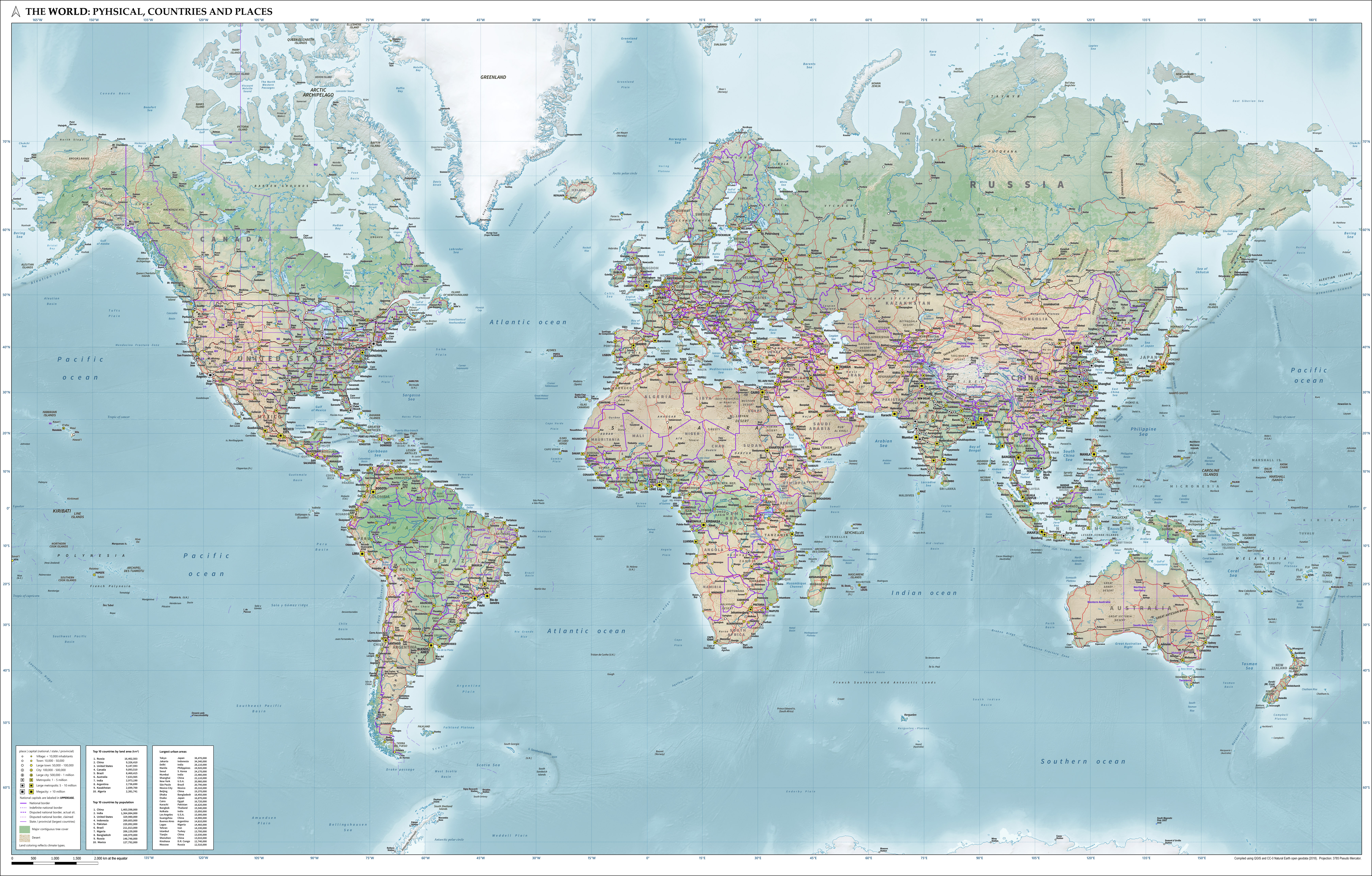
English: Combined map of the world in Pseudo Mercator projection showing physical, political and population characteristics, as per 2018. Compiled using QGIS and CC-0 Natural Earth data. Includes legend of symbols. |
| Dagur | |
| Kelda | Egið verk |
| Høvundur | Janwillemvanaalst |
Lisensur
I, the copyright holder of this work, hereby publish it under the following license:
This file is licensed under the Creative Commons Attribution 4.0 International license.
- Tú ert vælkomin til:
- at deila – at avrita, breiða út og senda verkið
- at remiksa – at tillaga ella broyta verkið
- Undir hesum treytum:
- ognan – Tú mást ognarskrivað verkið á ein slíkan hátt sum er útgreinaður av høvundanum ella lisenseigaranum (men ikki á nakran hátt ið kundi bent á at hesin hevur góðkent teg ella tína nýtslu av verkinum).
Søgan hjá fíluni
Trýst á dato/tíð fyri at síggja fíluna, sum hon sá út tá.
| Dagur/Tíð | Lítil mynd | Dimensjónir | Brúkari | Viðmerking | |
|---|---|---|---|---|---|
| streymur | 4. okt 2020 kl. 07:13 | | 6,944 × 4,432 (7.28 MB) | Janwillemvanaalst | Added additional regional labels, a few more places, and renamed the capital of Kazakhstan from Astana to Nur-Sultan. |
Nýtsla av fílu
Fylgjandi síða slóðar til hesa fílu:
.jpg)